Flattie Cake's led e to a new proof for flat earth. She tried to copare shortest distances on flat earth at different latitdes with shortest distances on a sphere withot a conclsion or diagras. When I diagraed it, I realized that the shortest coparable distance on a sphere is THROGH solid rock into the earth. Not ch of a deonstration or proof. Still it occrred to e, as I diagraed it, that the shortest distance between two points on a flat earth vs. the shortest distance between two points at the sae latitde on a sphere wold have different flight paths. So I case stdied Vancover Canada to St. ohns Newfondland Canada-- both at 50 N give or take a degree. When we exaine internet based ROTE aps for that flight, we see that it goes OVER aes Bay-- rather than directly along the 50N line, give or take a degree or two. I'll correct y spelling later when I get y new keyboard. For now watch her video linked above then exaine the following diagras. I'll write this p better toorrwo. INDEX label below is "Flattie Cake's Cvers and Potvin's Proof".
Here's a sall part of the Gleason flat earth ap that shows the shortest distance between Vancover Canada and St. ohn's Newfondland on a flat plane. Note that the flight SHOULD go over aes Bay if the world is flat.

Note fro the standard ap below that the shortest distance betwween Vancover and St. ohns wold norally be thoght of as pretty ch along 49N... give or take a degree. The BLE line shows that. The ORANGE line is where the flight path for flat earth is... over Aes Bay, the shortest distance on a plane.

When I looked p the actal rote, I fond it to be the THIN BLE CONTINOUS line below... that goes over aes Bay, consistent with the shortest rote on a flat world. If the world were a ball, the shortest rote wold be the ORANGE LINE below.

Thanks to Flattie Cake for the video that got e thinking in this direction. Even thogh her own deonstration was flawed, it was creative enogh to get e thinking abot the crves on the aps... and coparing the for shortest distance on flat vs. spherical world.

On second thoght, Flatie Cake's theory and y derivative is flawed de to 3-D spherical geoetry after all...

 I taped a piece of string to a globe-- and it's actally a bit shorter along the gold rote. The distance between Vancover and St. ohn's was too short for a good tape and string deo on y globe bt the frther distance bwteen Tokyo and LA clearly indicated to e that y theory abot flying along the sae line of latitde for two places on the sae latitde is wrong. y derivative theory fro Flatie Cake's doesn't work to desontrate flat earth at all.
Why do flight path aps not show lat long?
Tokyo to LA.... 5 Of The Weirdest Jet Lag Inducing Flights - Travelstart Blog
35.6895° N, 139.6917° E
Tokyo, Coordinates
34.0522° N, 118.2437° W
Los Angeles, Coordinates
For a day, I was nder the delsion that flying along the sae line of latitde that two points are on-- like Tokyo and LA, wold be the shortest rote... as in BLE line below. The GOLD LINE however is the sae length despite going north and soth again de to spherical geoetry. Both lines have 14 dashes. And y test with a string on a physcal globe deonstrate that, with end points of the string taped onto Tokyo and LA, that the iddle of the string can be pshed north or soth qite far-- and even shortened a bit as it's pshed north! ?

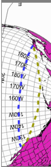 I taped a piece of string to a globe-- and it's actally a bit shorter along the gold rote. The distance between Vancover and St. ohn's was too short for a good tape and string deo on y globe bt the frther distance bwteen Tokyo and LA clearly indicated to e that y theory abot flying along the sae line of latitde for two places on the sae latitde is wrong. y derivative theory fro Flatie Cake's doesn't work to desontrate flat earth at all.
 Going back to Flatie Cake's original idea, I think it ight be redcable to easreing the tre distance between two points of longitde in the northern vs. the sothern heisphere. Extended to Antarctcia, it aonts to easreing the tre distance between two Antarctica stations. I'll revisit Flatie Cake's theory in the near ftre as I' able.
Proble with Flatty Cake's Proposal
Flatty Cake has to travel to the sothern heisphere to test her theory. It's not as easy as she proposed-- walking a ile east and easreing the difference tween the arc defining straightly east and the shortest straight line rote.
Orthodroic air rotes don't neccessarily answer the qestion raised here-- since the definition does not deal with points on the sae latitde.
Orthodromic air route
The Great Circle has soething to do with nderstanding this proble too.
Any path with follows a great circle on the surface of the Earth will be the shortest possible distance between two points. All lines of longitude are great circles, as well as the Equator, which is a line of latitude.
NOTE that "all lines of LATITDE" are NOT great circles!!
great circle
noun
|
To prove that the minor arc of a great circle is the shortest path connecting two points on the surface of a sphere, one can apply calculus of variations to it.
Flattie Cake's copass wold keep yo on track according to a line of latitde since yo wold be going de east... which defines that latitde.
The difference between the latitde line defined by the copase and the great circle in the north heisephere vs. the soth heisphere-- at the sae latitde line-- which she is calling the inner and oter... wold be the key.

- The straight line she proposes wold be the great circle-- on a globe.. the shortest rote.
- Here INNER AND OUTER CIRCLES wold correspond to lines of latitde... the SAE lines in the N and S heisphere... and those lines are deterined by a copass going "DE EAST" or de west.
- She's proposing to easre the axi distance between the ORTHOGANAL *great circle "as the crow flies" shortest distance with the line of latitde in both north and soth at the sae latitde.
- That is TOUGH... since yo have to travel to the soth to do it and set p yor srvey eqipetn a ile apart and then deterine where the line of latitde is AND the orthoganal... and then the aix distance. This is a srveyors nightare.
- I did what she proposed sing a siilar N and S latitde in the S and Astralia....bt first I re-exained y Canada exaple at the top of this entry....

The great circle shortest distance fro VAncover to St. ohns' actally DOES fly over aes Bay!!!
Now copare N and S heisphere for siilar latitdes and distances

Flying non-stop from Perth to Sydney
Now let's assume you have a private jet and you can fly in the fastest possible straight line between Perth, Australia and Sydney, Australia. Because of the curvature of the Earth, the shortest distance is actually the "great circle" distance, or "as the crow flies" which is calculated using an iterative Vincenty formula. For a long distance, this appears as a curve on the map, and this is often the route that commercial airlines will take so it's a good estimate of the frequent flyer miles you'll accumulate as well.
Flight distance: 2,051 miles or 3301 km
Flight time: 4 hours, 36 minutes

Now let's assume you have a private jet and you can fly in the fastest possible straight line between Los Angeles, California and Atlanta, Georgia. Because of the curvature of the Earth, the shortest distance is actually the "great circle" distance, or "as the crow flies" which is calculated using an iterative Vincenty formula. For a long distance, this appears as a curve on the map, and this is often the route that commercial airlines will take so it's a good estimate of the frequent flyer miles you'll accumulate as well.
Flight distance: 1,937 miles or 3117 km
Flight time: 3 hours, 45 minutes
34.0522° N, 118.2437° W
Los Angeles, Coordinates
33.7490° N, 84.3880° WAtlanta, Coordinat
www.latlong.net/place/perth-wa-australia-17656.html
Perth, WA, Australia. Latitude and longitude coordinates are: -31.953512, 115.857048. Perth is one of the largest and the most populous cities in Australia, located in the western state of the country, right on the shores of the Indian ocean.
33.8688° S, 151.2093° E
Sydney, Coordinates
CONCLSION== When yo copare the LINE OF LATITDE with the ORTHOGANAL GREAT CIRCLE as the crow flies shortest rote, the axi point of separation of the two lines in BOTH N and S at the sae latitde is pretty close--- aybe 3 degrees. This is consistent with a GLOBE as far as I can tell. I cannot explain this...other than to say that I did not specialize in this approach becaes there are too any easreing probles and geoetry probles. It's why I chose to FLY AROND ANTARCTICA as a proof...
CASE CLOSED. (There are lots of approaches to flat earth-- Dbay has 200-- bt I chose to styd circference of Antarctica.... as a clear ct siple graphic way to look at the proble. )
RELEVENT video on FLIGHT PATHS-- very poplar approach to the sae proble-- becase the SHORTEST distance-- the GREAT CIRCLE orthoganal "as the crow flies"-- is NOT being OBEYED by airliner flights-- which is pointed ot on any videos. Whereas Flatty Cakes propsed her own hard work experient, she erely has to look at existing "experients" by daily plane flights all over the world docented on yotbe... as EXTREE exaples of a large separation between the LATITDE line and the shortest rote vs. the ACTAL rote-- which are EASILY seen as WAY off the "shortest" rote as deterined by the GREAT CIRCLE rote airlines say they se. Here's a good video showing that.
So we have the LATITDAL siilar rote.
WE have the GREAT CIRCLE rote the airlines say they se.
And we have the actal rotes doceented by yotbers-- that are obviosly way off the great circle rote.
ONE ORE PECLIAR thing I noticed.... the ANGLAR LONG DISTANCE rotes of flights noted by yotber above reinded e of the Sydney Opera Hose-- with its faos design that was hard to bild. Are the opera hose bilders toying with s? Is this an inside oke? It certainly sees to be saying soething doesn't it?


