I found something called a "US Antarctic Inspection" series of which only the 1983 inpection tour has a map associated with it that shows an almost complete circumnavitation of Antarctica similar to what I envision doing myself to prove the place is either an island with a shoreline of about 15,000 miles or a rim around flat earth with a shoreline of 60,000 miles. You would think that this 1983 inspection tour would have been able to prove one or the other as long as the trip was documented. However, I can't verify any of the data on this tour so the shoreline length is still unconfirmed for my satisfaction. Still, this is a good reference point for many reasons.

source: http://www.loc.gov/resource/g9801f.ct002826/
MAP ENLARGEMENTS
(I would follow this exact route again, updating station by station. I would actually like to follow, day by day, the NEXT inspection tour. I would like to talk to someone online who was part of a complete circumnavigation tour-- or read a blog by someone who makes a complete circumnavigation tour)


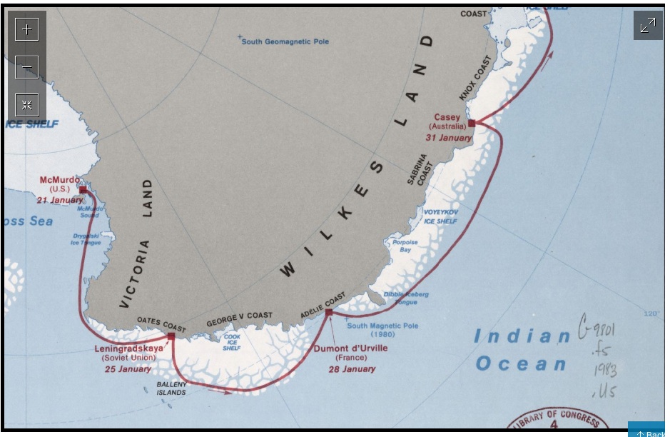
Pay attention to this last leg-- or NON leg of the inspection tour in 1983. It simply ENDS in McMurdo. There is NO ATTEMPT to go from McMurdo back to PALMER where the journey originated. You would think that just to make things "neat" and "tidy" that they would have gone on to Palmer just "for the heck of it" given the distance they had already covered. Besides, they could have "inspected" the shoreline between McMurdo and Palmer VISUALLY to see that there were no standing operations violating rules along that stretch. Furthermore, there WAS a Russian station along that coast and it WAS inhabited sporadically. Perhaps they SHOULD have gone in there as a LAST stop before the complete trip. But they didn't which raises suspicions again-- about this entire "Palmer Land" coast, "Ellesworth Land" and "Marie Byrd Land". NORTH of this stretch is the vast Pacific Ocean ... or at least the ANTARCTIC OCEAN-- south of the 60 degree Latitude-- called the Antarctic Convergence where "everything changes" from regular world ocean conditions for wildlife and climate to, sudden Antarctic conditions... this is in itself suspieious (see CONVERGENCE in index).

Here's what I got when I searched for OTHER YEARS' inspection tours.

Here's the Antarctic Convergence which I'll dive into more in another post-- see the INDEX BELOW under "convergence" or "difference - convergence". To find the above maps in detail again, look in the INDEX below under INSPECTION tours. I'm attempting to build a reference INDEX (not a search engine where the reader must come up with their own search terms). And index is a higher mode of data than a search engine. What I'm doing is processing wide search with a particular mission in mind and refining it to a categorical contents and alphabetical keyword index. I'm getting so good at it that I think I'll start including reports like this blog in my official resume.

quote
unquote
source: misplaced but findable on bing picture search under fuel depot map antarctica
What is the Antarctic convergence?
The Antarctic Convergence, also known as the Antarctic Polar Front marks the true outer edge of Antarctica. It is a circumpolar strip of sea around the southern most reaches of the Atlantic, Indian and Pacific oceans varying between about 45° and 60° South. It’s exact position is somewhat variable, but it is a very real and permanent feature. The surface temperature changes by 2-3°C from one side of the convergence (polar front) to the other.There is sufficient difference across the convergence that the seas around Antarctica are known as a distinct “Southern” or “Antarctic” ocean, rather than simply being the most southerly parts of the Atlantic, Indian and Pacific oceans.
unquote
It's interesting that Russkaya was never inspected during its lifetime [upto 1990] according to this file, although Byrd has been. [Annex 1]
ReplyDeletehttp://www.asoc.org/storage/documents/Meetings/ATCM/XXVI/ip-118.inspections.pdf
Why ever not??
Another of these amorphous inspections, this time by Australia, is documented here
http://www.antarctica.gov.au/about-us/publications/australian-antarctic-magazine/2006-2010/issue-18-2010/policy/australia-makes-flying-inspections
Our inspection activity covered in excess of 12 000 km, and was entirely supported by air.
The stations inspected are located on this map
http://www.antarctica.gov.au/about-us/publications/australian-antarctic-magazine/2006-2010/issue-18-2010/policy/australia-makes-flying-inspections
Note that one inspection comprised of several low passes over the [unoccupied Russian Molodezhnaya] station!
This internal US airfields inspection programme is equally abstract although it is not part of the Treaty inspections..
http://antarcticsun.usap.gov/features/contentHandler.cfm?id=1569
October 24, 2008
The mission of the 1st Aviation Standards Flight is to perform flight inspections of navigational-aid radar and instrument procedures at military and civilian installations in the United States and overseas....to Antarctica..
including the one at the South Pole Station External U.S. government site, making sure they are safe for aircraft ferrying supplies and hundreds of scientists and support personnel with the [NSF]
The inspection was primarily to test the Microwave Landing System, installed by Raytheon [q.v.] in addition...
We will be inspecting GPS approaches at the South Pole and around McMurdo.
I noted there's no map at the ASOC.org document. Good find though. Maybe I can map those out at some point. You found other inspection programs too-- amazing stuff. You would think with the degree of difficulty of moving around that alot of these inspections would be self-administered-- that Antarctica would be self-policing and rely on the honor system pretty much. Apparently there are, however, a police force-- These are "Antarctica Police"!... an entirely HIGHER layer of physical manueverability around Antarctica.
ReplyDelete